Compartir:

O verão em Portugal tem o seu encanto: tardes intermináveis, esplanadas cheias, o cheiro a pedra aquecida pelo sol. Mas nos últimos anos o calor passou de agradável a sufocante. E com mais uma época estival à porta, saber onde encontrar sombra deixou de ser um luxo — é uma necessidade real.
É aqui que entra o Shadowmap: um mapa interativo em 3D que indica, com precisão ao minuto, onde a sombra vai cair — em qualquer lugar do mundo.
Portugal e Espanha cada vez mais quentes — os dados não mentem
A Península Ibérica sempre teve um clima quente, mas a tendência é inegável. O verão de 2025 foi um dos dois mais quentes de sempre em Espanha, quase igualando o de 2022 — atualmente o mais quente registado. A onda de calor mais intensa de 2025, que atingiu em agosto, durou dezasseis dias com temperaturas 4,6 °C acima da média histórica — a maior anomalia alguma vez registada. Em Portugal, os verões recentes também bateram recordes consecutivos de temperatura máxima e de noites tropicais.
As boas notícias para 2026? As previsões apontam para que o calor forte chegue um pouco mais tarde do que é habitual — por volta de meados de junho em vez de maio — o que dará um arranque mais ameno à época. Mas quando o verão ibérico engata, engata a sério.
O panorama a longo prazo merece ser compreendido sem catastrofismo: a ciência climática projeta que, a meio do século, os verões mediterrânicos serão cerca de 2 °C mais quentes do que no período 1981–2020. Os verões de 2022 e 2025 já se aproximam dessas projeções de meados do século — o que torna a arte de viver com o calor uma competência cada vez mais indispensável.
As cidades aquecem mais do que o campo — e não é por acaso
Mesmo num dia de calor moderado, as cidades portuguesas e espanholas podem sentir-se vários graus mais quentes do que o campo. É o efeito ilha de calor urbana: consequência do betão, do asfalto, dos edifícios compactos e da falta de arborização, que retêm o calor e o irradiam bem dentro da noite.
Cidades como Lisboa, Porto, Madrid, Sevilha, Valência e Zaragoza tornam-se verdadeiros fornos durante o pico do verão. Bairros inteiros com pouca vegetação e pavimento dominante oferecem pouquíssimo refúgio durante as horas de maior calor — geralmente entre as 12h e as 18h.
Encontrar sombra neste ambiente nem sempre é tão simples como «encostar-se a uma árvore». A geometria do sol e das sombras numa malha urbana densa é surpreendentemente complexa. Que lado da rua estará à sombra às 16h de uma quarta-feira de julho? Essa esplanada onde pensas almoçar vai estar ao sol quando chegarem os pratos? É exatamente para isso que o Shadowmap foi criado.
O Que é o Shadowmap?
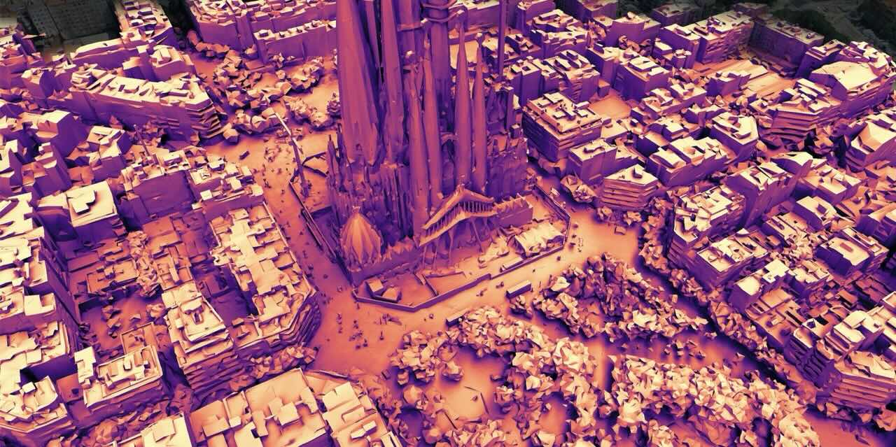
O Shadowmap é uma startup austríaca fundada em 2021 que utiliza dados reais de edifícios, terreno e arborização em 3D para simular a luz solar e as sombras em qualquer local, data e hora do dia. Pensa nele como um «Google Maps para o sol e a sombra» — um mapa interativo que sobrepõe os padrões de sombra sobre ruas, parques, praças e edifícios concretos.
Usá-lo é muito simples: escreve uma cidade ou morada, seleciona a data e a hora com os controlos deslizantes e observa como as zonas de sombra aparecem no mapa quase em tempo real. As zonas a azul-escuro indicam sombra; as douradas, sol direto. Move a barra de tempo para a frente e as sombras deslocam-se, permitindo-te planear a saída hora a hora.
Está disponível na web em shadowmap.org, bem como para iPhone e iPad via iOS.
Cinco formas de usar o Shadowmap em Portugal e Espanha
1. Planeia a tua saída do dia
É o uso mais prático e imediato. Antes de sair para o parque, o mercado ou uma volta pelo centro histórico, consulta o Shadowmap para identificar quais os percursos que ficam à sombra. Em cidades como Lisboa, Sevilha ou Valência, onde o sol a pino às 14h de agosto pode ser perigoso para idosos e crianças, uma consulta de cinco minutos pode fazer a diferença entre um passeio agradável e uma tarde de suplício. Podes planear o teu trajeto para andar sempre pelo lado da rua com sombra — ou pelo menos saber onde ficam os bancos e as esplanadas protegidas.

2. Encontra a esplanada ou café certo
A cultura da esplanada em Portugal dispensa apresentações, mas nem todas as esplanadas são iguais. Um sítio com sombra deliciosa às 19h de junho pode estar ao pleno sol às 20h. Com o Shadowmap podes verificar antecipadamente se uma esplanada específica estará à sombra à hora a que planeias chegar — e escolher em conformidade. Especialmente útil quando estás num bairro ou cidade que não conheces.
3. Escolhe onde viver — com mais conforto e poupança
Este é talvez o uso mais subvalorizado do Shadowmap no contexto ibérico, e pode representar uma poupança real. Quando procuras apartamento ou casa, a maioria dos anúncios diz-te a orientação do imóvel — mas raramente te conta a história completa da exposição solar ao longo do dia e das estações.
Com o Shadowmap podes colocar um marcador sobre qualquer edifício e percorrer as horas de um dia de verão para ver exatamente como o sol o atinge. Um apartamento que só recebe sol de manhã e fica à sombra a partir do início da tarde vai ser significativamente mais fresco durante o verão — o que se traduz em menos dependência do ar condicionado e uma fatura de eletricidade consideravelmente mais baixa. Pelo contrário, um apartamento voltado a oeste sem edifícios que o protejam vai acumular calor toda a tarde e não arrefecer até bem depois de anoitecer.
Para inquilinos e compradores em Portugal e Espanha, onde os custos energéticos no verão continuam a subir, este tipo de análise prévia pode influenciar uma decisão que afeta o teu bem-estar e as tuas despesas mensais durante anos.
4. Atividades ao ar livre, desporto e lazer
Ciclistas, corredores, donos de cães, pais com filhos pequenos — qualquer pessoa que passe tempo lá fora beneficia de saber quando e onde haverá sombra. O Shadowmap permite-te identificar quais os percursos do parque que ficam à sombra de manhã e quais de tarde, onde ficam os campos desportivos com sombra natural, ou como te posicionares num evento ao ar livre. É também uma ferramenta muito utilizada por fotógrafos e cineastas, que a usam para identificar quando uma fachada, uma praça ou uma paisagem terá luz difusa e suave em vez de sol duro e direto.
5. Planeamento de Painéis Solares
Se estás a pensar instalar painéis solares — cada vez mais comum em Portugal e Espanha dado o preço da energia — o Shadowmap ajuda-te a identificar quais os telhados e orientações que recebem maior exposição solar ao longo do ano. Também pode indicar-te quais as zonas sombreadas por edifícios vizinhos, evitando investimentos mal aproveitados.
Gratuito para Usar, com Funcionalidades Premium Disponíveis
A funcionalidade básica do Shadowmap — ver as sombras em tempo real e percorrer as horas do dia — é completamente gratuita. Qualquer utilizador pode aceder diretamente pelo browser ou através da app para iPhone, sem necessidade de criar conta.
As funcionalidades premium, disponíveis através de subscrições mensais ou anuais Home e Studio, desbloqueiam ferramentas adicionais: planeamento ao longo do ano, análise solar detalhada, e funções avançadas úteis para a procura de casa, instalação de painéis solares e aplicações profissionais em arquitetura, imobiliário e urbanismo.
Uma Pequena Ferramenta para um Grande Problema
O Shadowmap não vai resolver o problema da ilha de calor urbana. Para isso são precisas mais árvores, melhor desenho urbano, arquitetura mais verde e um planeamento de cidades mais inteligente — conversas que já estão em curso nas cidades portuguesas e espanholas, com maior ou menor urgência consoante o caso.
Mas enquanto cidades e governos se atualizam, ferramentas como o Shadowmap oferecem algo silenciosamente poderoso: a capacidade de tomar melhores decisões, dia a dia e rua a rua, num território que se torna cada ano notavelmente mais quente. Seja a escolher o percurso da corrida matinal em Lisboa, a procurar um apartamento fresco no Porto, ou a encontrar a esplanada mais agradável de Sevilha numa tarde de julho, saber onde caem as sombras é um conhecimento que vale a pena ter.
Experimente em shadowmap.org — sem instalação, sem conta, grátis.
Compartilhar este artigo:

SAIBA MAIS
Visões esclarecedoras


Como visto em


